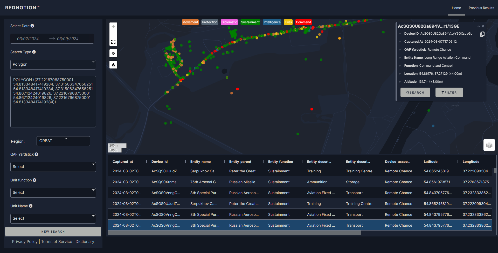
One strategic intelligence agency situated in Europe needs detailed understanding of the changing crisis in Ukraine. Statistique developed a safe, real-time dashboard offering a complete picture of military activity—including unit locations, supply lines, and defensive positions—by using satellite imagery, mobile phone data, and advanced GIS tools. Applied on Google Big Query and shown on Dash Plotly, the approach significantly influences decision-making for important defense stakeholders including the U.S. Army.
Project Overview
- Client: A strategic intelligence organization in the European Union
- Objective: Track and visualize ongoing military operations in Ukraine using geospatial and open-source intelligence (OSINT) data
- Scope: End-to-end development—from data acquisition and pipeline setup to visualization, secure access management, and real-time analytics
Key Components of the Solution
1. Secure Data Ingestion & Storage
- Google BigQuery: We centralized massive volumes of satellite and cell phone data into a single, scalable data warehouse. This enabled near-instant retrieval of geospatial insights, no matter the size of the dataset.
- APIs & Custom Connectors: Automated pipelines pulled in real-time intelligence from multiple sources, reducing manual overhead and enhancing data accuracy.
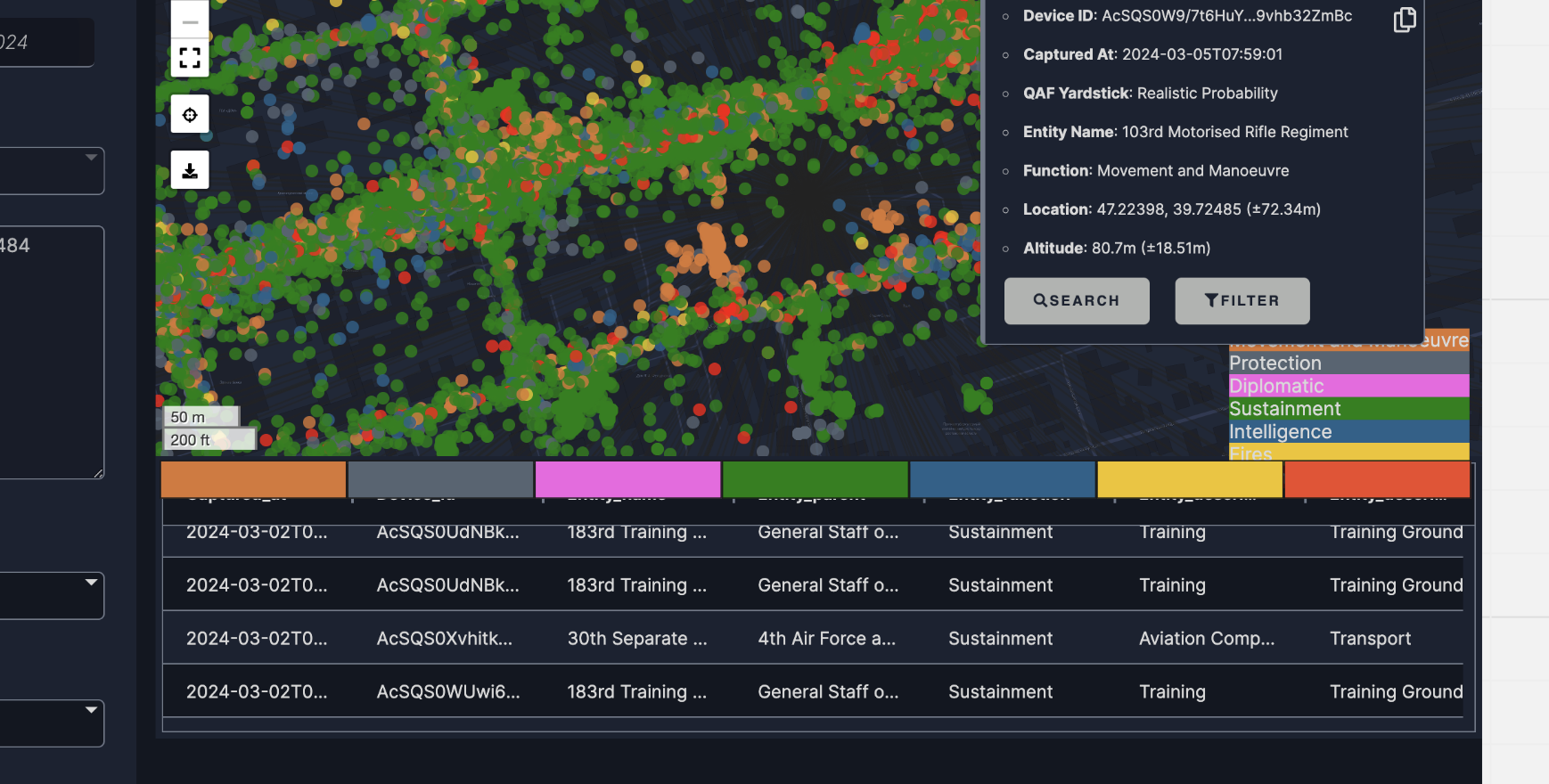
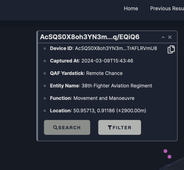
2. GIS-Driven Analytics
The system fused location-based intelligence with detailed metadata about military units:
- Satellite Imagery Integration: Algorithms correlated troop movements, supply routes, and camp locations with high-resolution imagery.
- Cell Phone Data Correlation: Tracked communications footprints to identify active or idle units, as well as possible staging sites.
- Defensive Strategy Mapping: Overlaid known fortifications and defensive lines to spot potential vulnerabilities or strategic chokepoints.
3. Interactive Dashboards with Dash Plotly
We built a password-protected, role-based web application showcasing real-time maps, charts, and intelligence layers:
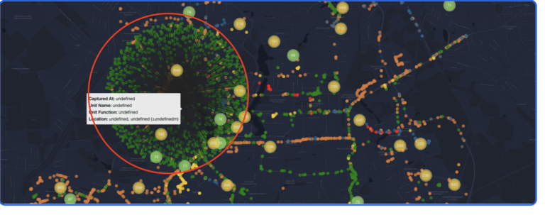
- Drill-Down Views: From a broad geographic overview down to specific units, enabling analysts to investigate crucial details with a few clicks.
- Layered Geospatial Data: Distinct layers for troop locations, vehicle movements, and defense lines, offering a unified lens on multi-pronged battlefield developments.
- Custom Alerts & Filters: Flags suspicious movements and highlights newly identified camps or potential massing of forces.
4. Enterprise-Grade Security
Given the sensitive nature of wartime intelligence:
- Secure Access Protocols: Encrypted connections and multi-factor authentication restricted dashboard entry to authorized personnel only.
- Granular Permissions: Role-based controls ensured that sensitive data—like coordinates of specialized units—remained visible only to individuals with the proper clearance.
Results & Impact
- Real-Time Situational Awareness
The integrated dashboard enables military planners and analysts to react fast to changing front lines, therefore enabling their anticipation of probable escalations or breakthroughs. - Improved Decision-Making for Defense Stakeholders
Enhanced Decision-Making for Defense Participants Seeing open-source intelligence in one pane of glass helps the U.S. Army and allies rapidly organize military deployments, protect supply lines, and maximize strategic posture. - Efficient Resource Allocation
Automated intake and analytics free several hours of labor-intensive data sorting, allowing intelligence teams to concentrate on diplomatic advice, deeper research, and scenario planning. - Scalable for Future Conflict Monitoring
Built on robust cloud infrastructure, the system can easily accommodate additional data sources, new geographic areas, or evolving intelligence paradigms—ensuring continued relevance and adaptability.
Why Statistique?
By blending advanced analytics, secure architecture, and GIS expertise, Statistique delivers mission-critical insights that inform high-stakes decisions. Our proven track record in data consolidation, real-time intelligence, and intuitive visualization sets us apart—whether for strategic warfare analysis or any other domain requiring actionable data.
Want to let your data really shine? Get in touch to find out how our customized solutions might provide your next major project security, agility, and clarity.